
Sandringham topographic map
Click on the map to display elevation.
About this map
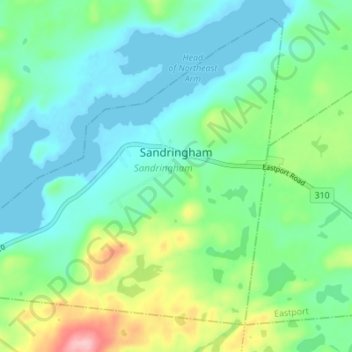
Name: Sandringham topographic map, elevation, terrain.
Location: Sandringham, Newfoundland, Newfoundland and Labrador, Canada (48.64412 -53.88071 48.68363 -53.80226)
Average elevation: 42 m
Minimum elevation: -1 m
Maximum elevation: 160 m
Other topographic maps
Click on a map to view its topography, its elevation and its terrain.
Avalon Peninsula
Canada > Newfoundland and Labrador > Spaniard's Bay > Tilton
Average elevation: 157 m
Signal Hill National Historic Site
Canada > Newfoundland and Labrador > St. John's
Average elevation: 29 m
Middle Cove
Canada > Newfoundland and Labrador > Logy Bay-Middle Cove-Outer Cove
Average elevation: 41 m
St Vincent's
Canada > Newfoundland and Labrador > St. Vincent's - St. Stephen's - Peter's River
Average elevation: 40 m