
Koshi topographic map
Interactive map
Click on the map to display elevation.
About this map
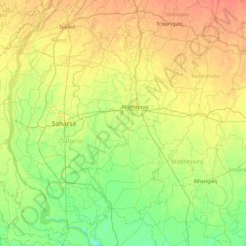
Name: Koshi topographic map, elevation, terrain.
Location: Koshi, Madhepura, Bihar, 852218, India (25.56630 86.67474 26.18387 86.81117)
Average elevation: 45 m
Minimum elevation: 31 m
Maximum elevation: 61 m
Other topographic maps
Click on a map to view its topography, its elevation and its terrain.
Dinapur-Cum-Khagaul
Dinapur-Cum-Khagaul, Patna District, Bihar, India
Average elevation: 51 m
Manikpur
India > Bihar > Narpatganj > Manikpur
Manikpur, Narpatganj, Araria, Bihar, 854336, India
Average elevation: 70 m
Gaya
India > Bihar > Gaya Town C.D.Block > Gaya
Gaya, Gaya Town C.D.Block, Gaya, Bihar, 823001, India
Average elevation: 111 m