
Modena topographic map
Interactive map
Click on the map to display elevation.
About this map
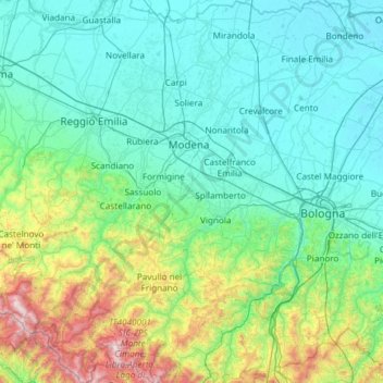
Name: Modena topographic map, elevation, terrain.
Location: Modena, Emilia-Romagna, Italy (44.11415 10.46983 44.96295 11.36893)
Average elevation: 319 m
Minimum elevation: 5 m
Maximum elevation: 2,112 m
Other topographic maps
Click on a map to view its topography, its elevation and its terrain.