
Ausserberg topographic map
Interactive map
Click on the map to display elevation.
About this map
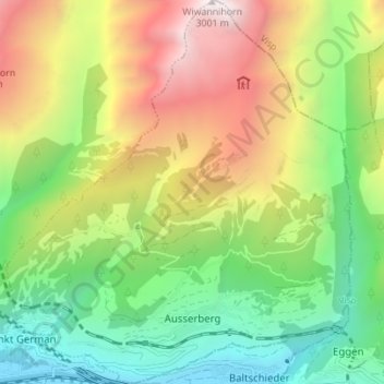
Name: Ausserberg topographic map, elevation, terrain.
Location: Ausserberg, Westlich Raron, Valais/Wallis, Switzerland (46.30718 7.81901 46.35498 7.88132)
Average elevation: 1,580 m
Minimum elevation: 638 m
Maximum elevation: 2,997 m
The municipality is located in the Westlich Raron district, on the northern slope of the Rhone valley between the Baltschiederbach and the Bietschhorn mountain. It consists of a number of scattered settlements with the central village of Trogdorf at an elevation of 1,008 m (3,307 ft).