
Marion County topographic map
Interactive map
Click on the map to display elevation.
About this map
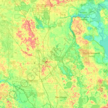
Name: Marion County topographic map, elevation, terrain.
Location: Marion County, Florida, United States of America (28.95980 -82.53595 29.52168 -81.63893)
Average elevation: 24 m
Minimum elevation: 0 m
Maximum elevation: 70 m
Other topographic maps
Click on a map to view its topography, its elevation and its terrain.
Country Club Manor
United States of America > Florida > Sanford > Country Club Manor
Average elevation: 14 m
Daytona Park Estates
United States of America > Florida > Daytona Park Estates
Average elevation: 20 m
Presbyterian Villas Of Lehigh
United States of America > Florida > Presbyterian Villas Of Lehigh
Average elevation: 10 m