
Distrito Las Cuevas topographic map
Interactive map
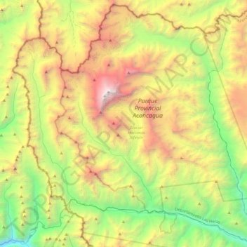
Click on the map to display elevation.
About this map
Name: Distrito Las Cuevas topographic map, elevation, terrain.
Average elevation: 4,019 m
Minimum elevation: 2,131 m
Maximum elevation: 6,946 m
Other topographic maps
Click on a map to view its topography, its elevation and its terrain.
Aconcagua
Argentina > Mendoza > Distrito Las Cuevas
Aconcagua (Spanish pronunciation: [akoŋˈkaɣwa]) is a mountain in the Principal Cordillera of the Andes mountain range, in Mendoza Province, Argentina. It is the highest mountain in the Americas, the highest outside Asia, and the highest in both the Western Hemisphere and the Southern Hemisphere with a…
Average elevation: 6,201 m
Maipo
Argentina > Mendoza > Distrito Pareditas
The region's climate is transitional between the drier Mediterranean climate of the peaks to the north and the cold, moist climate of Chilean Patagonia. Hence, while less glaciated than Patagonia, it has more permanent snow on the wet, Chilean side than peaks of similar elevation to the north.
Average elevation: 4,747 m