
Patan topographic map
Interactive map
Click on the map to display elevation.
About this map
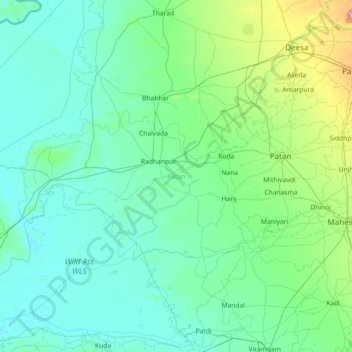
Name: Patan topographic map, elevation, terrain.
Location: Patan, Gujarat, India (23.39265 71.03397 24.15454 72.48155)
Average elevation: 45 m
Minimum elevation: 0 m
Maximum elevation: 473 m
Other topographic maps
Click on a map to view its topography, its elevation and its terrain.
Rampura
India > Gujarat > Detroj Rampura Taluka
Rampura, Detroj Rampura Taluka, Ahmedabad District, Gujarat, 382140, India
Average elevation: 42 m
Dantiwada dam
India > Gujarat > Dantiwada Taluka > Dantiwada
Dantiwada dam, Dantiwada, Dantiwada Taluka, Banaskantha District, Gujarat, 385505, India
Average elevation: 170 m
Rajkot
India > Gujarat > Rajkot East Taluka
Rajkot, Rajkot East Taluka, Rajkot District, Gujarat, 360001, India
Average elevation: 141 m
Bhuj
India > Gujarat > Bhuj Taluka
Bhuj, Bhuj Taluka, Kachchh, Gujarat, 370001, India
Average elevation: 130 m