
Kapisa Province topographic map
Interactive map
Click on the map to display elevation.
About this map
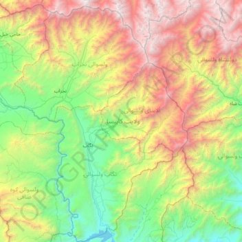
Name: Kapisa Province topographic map, elevation, terrain.
Location: Kapisa Province, Afghanistan (34.63414 69.27460 35.18496 69.92643)
Average elevation: 2,387 m
Minimum elevation: 1,032 m
Maximum elevation: 4,895 m
Other topographic maps
Click on a map to view its topography, its elevation and its terrain.
Kandahar
Afghanistan > Kandahar Province > Kandahar
Kandahar (English: /ˈkændəhɑːr/; Pashto: کندهار, romanized: Kandahār; Dari: قندهار, romanized: Qandahār) is a city in Afghanistan, located in the south of the country on the Arghandab River, at an elevation of 1,010 m (3,310 ft). It is Afghanistan's second largest city after Kabul, with a…
Average elevation: 1,048 m
Kabul
Afghanistan > Kabul Province > Kabul District
The modern-day city of Kabul is located high up in a narrow valley in the Hindu Kush, and is bounded by the Kabul River. At an elevation of 1,790 metres (5,873 ft), it is one of the highest capital cities in the world. The center of this city includes its old neighborhoods, which include the areas of Khashti…
Average elevation: 1,945 m