Nanning topographic map
Interactive map
Click on the map to display elevation.
About this map
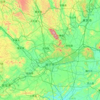
Name: Nanning topographic map, elevation, terrain.
Location: Nanning, Guangxi, China (22.20652 107.32456 24.03478 109.61818)
Average elevation: 225 m
Minimum elevation: 10 m
Maximum elevation: 1,721 m
Nanning is situated in a hilly basin with elevations between 70 and 500 m (230 and 1,640 ft) above sea-level. Qingxiu Mountain dominates the southern part of town.
Other topographic maps
Click on a map to view its topography, its elevation and its terrain.
Zhongshan
China > Guangxi > Zhongshan County
Zhongshan, Zhongshan County, Hezhou, Guangxi, China
Average elevation: 246 m
Lingchuan County
Lingchuan County, Guilin, Guangxi, 541203, China
Average elevation: 431 m
Long'an County
Long'an County, Nanning, Guangxi, China
Average elevation: 255 m
Guanyang County
Guanyang County, Guilin, Guangxi, 541607, China
Average elevation: 635 m
Luocheng Mulao Autonomous County
Luocheng Mulao Autonomous County, Yule, Hechi, Guangxi, China
Average elevation: 226 m
Pingnan County
Pingnan County, Chini, Guigang, Guangxi, China
Average elevation: 36 m