
Rio Blanco County topographic map
Interactive map
Click on the map to display elevation.
About this map
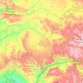
Name: Rio Blanco County topographic map, elevation, terrain.
Location: Rio Blanco County, Colorado, United States of America (39.65216 -109.05129 40.22606 -107.03745)
Average elevation: 2,161 m
Minimum elevation: 1,347 m
Maximum elevation: 3,863 m
Other topographic maps
Click on a map to view its topography, its elevation and its terrain.
Crested Butte
United States of America > Colorado > Crested Butte
Crested Butte is located in north-central Gunnison County on the west side of the valley of the Slate River, along Coal Creek. Colorado State Highway 135 runs south from Crested Butte 27 miles (43 km) to Gunnison, the county seat. According to the United States Census Bureau, the town of Crested Butte has a…
Average elevation: 2,798 m