
Douglas County topographic map
Interactive map
Click on the map to display elevation.
Douglas County
According to the U.S. Census Bureau, the county has an area of 738 square miles (1,910 km2), of which 710 square miles (1,800 km2) is land and 28 square miles (73 km2) (3.8%) is water. It is the second-smallest county in Nevada by area. The highest point is East Peak at 9,593 ft (2,924 m), while the most topographically prominent mountain is Mount Siegel.
About this map
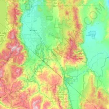
Name: Douglas County topographic map, elevation, terrain.
Location: Douglas County, Nevada, United States of America (38.53617 -120.00343 39.11401 -119.31548)
Average elevation: 1,940 m
Minimum elevation: 1,345 m
Maximum elevation: 3,308 m