
Alvesta kommun topographic map
Interactive map
Click on the map to display elevation.
About this map
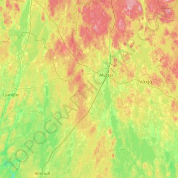
Name: Alvesta kommun topographic map, elevation, terrain.
Location: Alvesta kommun, Kronoberg County, Region Götaland, Sweden (56.53402 14.27828 57.16336 14.69556)
Average elevation: 168 m
Minimum elevation: 105 m
Maximum elevation: 296 m
Other topographic maps
Click on a map to view its topography, its elevation and its terrain.
Skärsjön
Sweden > Kronoberg County > Markaryd
Skärsjön, Kullastigen, Markaryd, Markaryds kommun, Kronoberg County, Region Götaland, Sweden
Average elevation: 101 m