
Bowman County topographic map
Interactive map
Click on the map to display elevation.
About this map
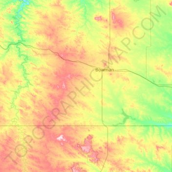
Name: Bowman County topographic map, elevation, terrain.
Location: Bowman County, North Dakota, United States of America (45.94513 -104.04682 46.28085 -102.99556)
Average elevation: 899 m
Minimum elevation: 791 m
Maximum elevation: 1,099 m
Other topographic maps
Click on a map to view its topography, its elevation and its terrain.
Haynes
United States of America > North Dakota > Haynes > Haynes
Haynes, Adams County, North Dakota, United States of America
Average elevation: 790 m
Hannah
United States of America > North Dakota > Hannah
Hannah, Cavalier County, North Dakota, United States of America
Average elevation: 476 m
Barney
United States of America > North Dakota > Barney
Barney, Richland County, North Dakota, United States of America
Average elevation: 316 m
Flaxton
United States of America > North Dakota > Flaxton > Flaxton
Flaxton, Burke County, North Dakota, United States of America
Average elevation: 590 m
Avoca
United States of America > North Dakota > Avoca
Avoca, Williams County, North Dakota, United States of America
Average elevation: 625 m
New England
United States of America > North Dakota > New England
New England, Hettinger County, North Dakota, 58647, United States of America
Average elevation: 793 m
Buxton
United States of America > North Dakota > Buxton
Buxton, Traill County, North Dakota, United States of America
Average elevation: 285 m
Billings County
United States of America > North Dakota
Billings County, North Dakota, United States of America
Average elevation: 790 m
Leith
United States of America > North Dakota > Leith
Leith, Grant County, North Dakota, United States of America
Average elevation: 714 m