
Eugene topographic map
Interactive map
Click on the map to display elevation.
Eugene
According to the United States Census Bureau, the city has a total area of 43.74 square miles (113.29 km2), of which 43.72 square miles (113.23 km2) is land and 0.02 square miles (0.05 km2) is water. Eugene is at an elevation of 426 feet (130 m).
About this map
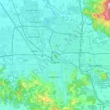
Name: Eugene topographic map, elevation, terrain.
Location: Eugene, Lane County, Oregon, United States (43.98753 -123.20876 44.13232 -123.03059)
Average elevation: 163 m
Minimum elevation: 88 m
Maximum elevation: 689 m
Other topographic maps
Click on a map to view its topography, its elevation and its terrain.
Thurston Hills Natural Area
United States > Oregon > Lane County > Springfield
Average elevation: 324 m