
Trujillo topographic map
Interactive map
Click on the map to display elevation.
About this map
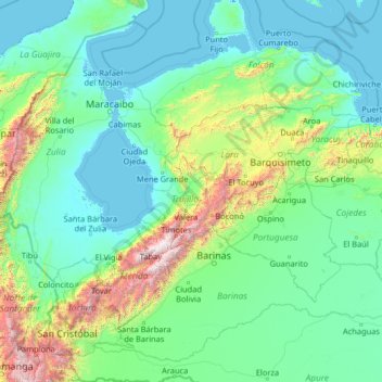
Name: Trujillo topographic map, elevation, terrain.
Location: Trujillo, Venezuela (6.97215 -73.13631 12.17215 -67.93631)
Average elevation: 385 m
Minimum elevation: -6 m
Maximum elevation: 4,773 m
Other topographic maps
Click on a map to view its topography, its elevation and its terrain.
Anzoategui State
The vegetation of the Anzoátegui State is typical temperate. It is largely determined by altitude, climate and season of the year, where areas of snow-covered scrub, cujíes and small southern species alternate. It also has a tree called caderoms, this includes resistant or environmentally adapted varieties.
Average elevation: 156 m
Villa Rosa
Venezuela > Anzoategui State > Municipio Simón Rodríguez > El Tigre
Average elevation: 281 m
Ciudad Guayana (Puerto Ordaz)
Venezuela > Bolivar State > Ciudad Guayana (Puerto Ordaz)
Average elevation: 73 m
Caracas
Venezuela > Capital District > Municipio Libertador
Caracas is contained entirely within a valley of the Venezuelan Central Range, and is separated from the Caribbean coast by a roughly 15-kilometer (9 mi) expanse of El Ávila National Park. The valley is relatively small and quite irregular, and the altitude varies from between 870 and 1,043 meters (2,854 and…
Average elevation: 727 m
Lara State
Lara's topography consist of high plains and low, broken hills, with a relatively hot and dry climate. Lara depression is located at altitudes between 1,600 and 2,600 ft (487 to 792 m). Among the landscapes of moderate height, the pressures of Carora, Barquisimeto and Yaracuy stand out, while the Sierra de…
Average elevation: 650 m