
Sanggau topographic map
Interactive map
Click on the map to display elevation.
About this map
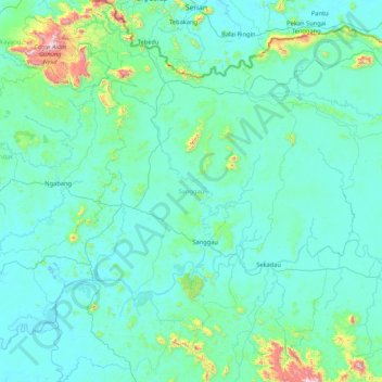
Name: Sanggau topographic map, elevation, terrain.
Location: Sanggau, West Kalimantan, Kalimantan, Indonesia (-0.49952 109.84214 1.19993 111.01312)
Average elevation: 106 m
Minimum elevation: -1 m
Maximum elevation: 1,563 m
Sanggau Regency borders Sintang and Sekadau Regencies in the east, Malaysia in the north, Ketapang Regency in the south, and Landak Regency in the west. Sanggau Regency is located in the interior of Borneo, and is divided by the Kapuas River, which is one of the longest rivers in Indonesia. Its topography is dominated by wetlands and swamps, which are generally low-lying. The regency's soil formation is dominated by podzol, which covers around 44% of the regency's area. In Toba and Meliau District, latosol soil can be found.
Other topographic maps
Click on a map to view its topography, its elevation and its terrain.
Siantan Hulu
Indonesia > West Kalimantan > Pontianak
Siantan Hulu, Pontianak Utara, Pontianak, West Kalimantan, Indonesia
Average elevation: 4 m
Condong
Indonesia > West Kalimantan > Singkawang > Condong
Condong, Singkawang, West Kalimantan, 79113, Indonesia
Average elevation: 4 m
Sanggau
Indonesia > West Kalimantan > Sanggau
Sanggau, West Kalimantan, Indonesia
Average elevation: 42 m
Kapuas River
Kapuas River, West Kalimantan, 78611, Indonesia
Average elevation: 141 m