
Bojanala Platinum District Municipality topographic map
Interactive map
Click on the map to display elevation.
About this map
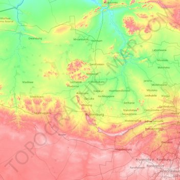
Name: Bojanala Platinum District Municipality topographic map, elevation, terrain.
Average elevation: 1,240 m
Minimum elevation: 898 m
Maximum elevation: 1,835 m
Other topographic maps
Click on a map to view its topography, its elevation and its terrain.
Rustenburg
South Africa > North West > Bojanala Platinum District Municipality
Rustenburg has a humid subtropical climate (Köppen Cwa), with a relatively high degree of diurnal temperature variation due to the high elevation. It has very warm summers (from December to February) and mild winters (from June to August). Due to the altitude, summers are not quite as hot as one might expect.…
Average elevation: 1,217 m