
Make a donation
Gear up for your next adventure:
As an Amazon Associate, this site earns from qualifying purchases at no extra cost to you.
Keene topographic map
Click on the map to display elevation.
Make a donation
Gear up for your next adventure:
As an Amazon Associate, this site earns from qualifying purchases at no extra cost to you.
About this map
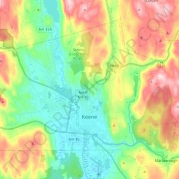
Name: Keene topographic map, elevation, terrain.
Location: Keene, Cheshire County, New Hampshire, United States (42.90426 -72.38291 43.00003 -72.21706)
Average elevation: 263 m
Minimum elevation: 134 m
Maximum elevation: 474 m
Make a donation
Gear up for your next adventure:
As an Amazon Associate, this site earns from qualifying purchases at no extra cost to you.
Other topographic maps
Click on a map to view its topography, its elevation and its terrain.
The Branch
United States > New Hampshire > Cheshire County > Keene > South Keene
Average elevation: 181 m
North Swanzey
United States > New Hampshire > Cheshire County > Keene > North Swanzey
Average elevation: 169 m