
Todd County topographic map
Interactive map
Click on the map to display elevation.
About this map
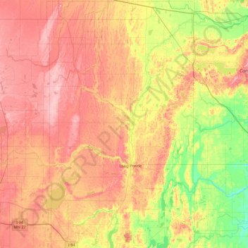
Name: Todd County topographic map, elevation, terrain.
Location: Todd County, Minnesota, United States of America (45.77440 -95.15633 46.37078 -94.64186)
Average elevation: 403 m
Minimum elevation: 343 m
Maximum elevation: 459 m
Other topographic maps
Click on a map to view its topography, its elevation and its terrain.
Brooklyn Park
United States of America > Minnesota > Brooklyn Park
Brooklyn Park, Hennepin County, Minnesota, United States of America
Average elevation: 265 m
Stevens County
United States of America > Minnesota
Stevens County, Minnesota, United States of America
Average elevation: 345 m
Farmington
United States of America > Minnesota > Farmington
Farmington, Dakota County, Minnesota, 55024, United States of America
Average elevation: 280 m
Fairmont
United States of America > Minnesota > Fairmont
Fairmont, Martin County, Minnesota, 56031, United States of America
Average elevation: 361 m
Apple Valley
United States of America > Minnesota > Apple Valley
Apple Valley, Dakota County, Minnesota, 55124, United States of America
Average elevation: 301 m
Greenbush
United States of America > Minnesota > Greenbush
Greenbush, Roseau County, Minnesota, 56726, United States of America
Average elevation: 324 m
Lake Itasca
United States of America > Minnesota > Lake Itasca
Lake Itasca, Clearwater County, Minnesota, 56480, United States of America
Average elevation: 460 m
Beaver Creek
United States of America > Minnesota > Beaver Creek
Beaver Creek, Rock County, Minnesota, 56116, United States of America
Average elevation: 447 m
Brownton
United States of America > Minnesota > Brownton
Brownton, McLeod County, Minnesota, United States of America
Average elevation: 314 m
Birchmont
United States of America > Minnesota > Birchmont
Birchmont, Beltrami County, Minnesota, 56601, United States of America
Average elevation: 419 m
Erskine
United States of America > Minnesota > Erskine
Erskine, Polk County, Minnesota, United States of America
Average elevation: 365 m
Etna Creek
United States of America > Minnesota
Etna Creek, Fillmore County, Minnesota, United States of America
Average elevation: 404 m
Watson
United States of America > Minnesota > Watson
Watson, Chippewa County, Minnesota, United States of America
Average elevation: 305 m
Maple Grove
United States of America > Minnesota > Maple Grove
Maple Grove, Hennepin County, Minnesota, United States of America
Average elevation: 280 m
New Ulm
United States of America > Minnesota > New Ulm
New Ulm, Brown County, Minnesota, 56073, United States of America
Average elevation: 278 m
Red Lake County
United States of America > Minnesota
Red Lake County, Minnesota, United States of America
Average elevation: 341 m