
Make a donation
Gear up for your next adventure:
As an Amazon Associate, this site earns from qualifying purchases at no extra cost to you.
Idlib District topographic map
Click on the map to display elevation.
Make a donation
Gear up for your next adventure:
As an Amazon Associate, this site earns from qualifying purchases at no extra cost to you.
About this map
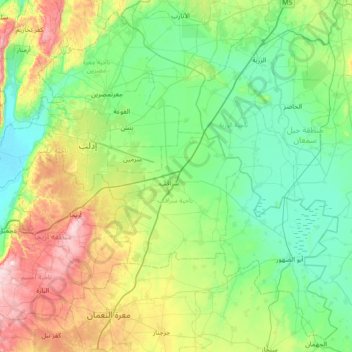
Name: Idlib District topographic map, elevation, terrain.
Location: Idlib District, Idlib Governorate, Syria (35.60473 36.42950 36.14367 37.14396)
Average elevation: 392 m
Minimum elevation: 215 m
Maximum elevation: 919 m
Make a donation
Gear up for your next adventure:
As an Amazon Associate, this site earns from qualifying purchases at no extra cost to you.
Other topographic maps
Click on a map to view its topography, its elevation and its terrain.
Has
Hass (Arabic: حَاسٌّ, romanized: Ḥāss) is a town in northwestern Syria, administratively part of the Ma'arrat al-Numan District of the Idlib Governorate. The town has an altitude of 630 meters above sea level. According to the Syria Central Bureau of Statistics, Hass had a population of 9,595 in the…
Average elevation: 591 m