
Nottingham topographic map
Interactive map
Click on the map to display elevation.
About this map
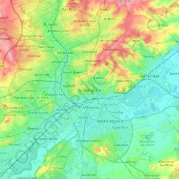
Name: Nottingham topographic map, elevation, terrain.
Location: Nottingham, Nottinghamshire, England, United Kingdom (52.88901 -1.24696 53.01867 -1.08612)
Average elevation: 56 m
Minimum elevation: 16 m
Maximum elevation: 140 m
Other topographic maps
Click on a map to view its topography, its elevation and its terrain.
Halam CP
United Kingdom > England > Nottinghamshire > Newark and Sherwood
Halam CP, Newark and Sherwood, Nottinghamshire, England, United Kingdom
Average elevation: 57 m
Mansfield Woodhouse
United Kingdom > England > Nottinghamshire
Mansfield Woodhouse, Mansfield, Nottinghamshire, England, NG19 8AN, United Kingdom
Average elevation: 114 m
East Stoke CP
United Kingdom > England > Nottinghamshire > Newark and Sherwood
East Stoke CP, Newark and Sherwood, Nottinghamshire, England, United Kingdom
Average elevation: 24 m
Rushcliffe
United Kingdom > England > Nottinghamshire
Rushcliffe, Nottinghamshire, England, United Kingdom
Average elevation: 63 m
Eastwood CP
United Kingdom > England > Nottinghamshire > Broxtowe
Eastwood CP, Broxtowe, Nottinghamshire, England, United Kingdom
Average elevation: 81 m
Carlton
United Kingdom > England > Nottinghamshire > Gedling
Carlton, Gedling, Nottinghamshire, England, NG4 1SR, United Kingdom
Average elevation: 51 m
Epperstone CP
United Kingdom > England > Nottinghamshire > Newark and Sherwood
Epperstone CP, Newark and Sherwood, Nottinghamshire, England, United Kingdom
Average elevation: 69 m
Hucknall
United Kingdom > England > Nottinghamshire > Ashfield > Hucknall
Hucknall, Ashfield, Nottinghamshire, East Midlands, England, NG15 7BA, United Kingdom
Average elevation: 104 m