
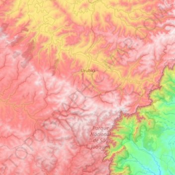
Urubici topographic map
Interactive map
Click on the map to display elevation.
About this map
Name: Urubici topographic map, elevation, terrain.
Average elevation: 1,151 m
Minimum elevation: 179 m
Maximum elevation: 1,812 m
The town of Urubici was founded in 1915, as the village of São Joaquim. Today, its natural beauties attract tourists and backpackers from all corners of Brazil looking for the landscapes of the mountain ridge of the state of Santa Catarina. Located in the valley of the Canoas river, the town has in its hills, valleys, trails and waterfalls places for those who want to rest or go for ecotourism and adventure tourism. Urubici is part of the São Joaquim National park, which is very rich in flora and fauna. The park has an area of 493 km2 (190 sq mi) and is divided between the fields on top of the ridge, where we have the lowest temperatures in Brazil, and the area at the foot of the ridge, with temperature around the 20 °C (68 °F). A visit to it reveals incredible landscapes, such as the Laranjeiras Canyon (Canyon of the Orange Trees) and the famous Pedra Furada (Holed Rock), which can be seen from the Morro da Igreja (Church Hill), known as the highest point in the South of Brazil, with 1,827 meters (5,994.09 ft.) of altitude. In the surroundings of the town there are other places that deserve a visit, such as the Avencal Waterfall, with 100 meters (328.08 ft.) of free fall, and indigenous caves that are found in the area. There it is possible to see rupestral engravings which date back to more than four thousand years ago. In the severe winter, between the months of June and August, there can be some snow, which gives a European appearance to its streets. In 1996, the town registered the lowest temperature ever recorded in thermometers in Brazil, −17.8 °C (0.04 °F). It is the ideal weather for those who like chatting in front of a fireplace, sipping some good wine, or just relax. Throughout its history, Urubici suffered the influence of Portuguese, Italian, German, African and Latvian settlers, who have left their characteristics in its culture, arts, architecture, and cuisine. The city is also known as the land of the vegetables because of the variety and quality of the local production.
Other topographic maps
Click on a map to view its topography, its elevation and its terrain.
Itá
Itá, Região Geográfica Imediata de Concórdia, Região Geográfica Intermediária de Chapecó, Santa Catarina, South Region, 89760-000, Brazil
Average elevation: 470 m
São Joaquim
São Joaquim, Região Geográfica Imediata de Lages, Região Geográfica Intermediária de Lages, Santa Catarina, South Region, 88600-000, Brazil
Average elevation: 1,187 m
Balneário Camboriú
Brazil > Santa Catarina > Balneário Camboriú
Balneário Camboriú, Região Geográfica Imediata de Itajaí, Região Geográfica Intermediária de Blumenau, Santa Catarina, South Region, Brazil
Average elevation: 41 m
Balneário Piçarras
Brazil > Santa Catarina > Balneário Piçarras
Balneário Piçarras, Região Geográfica Imediata de Itajaí, Região Geográfica Intermediária de Blumenau, Santa Catarina, South Region, 88380-000, Brazil
Average elevation: 15 m
Paraíso
Brazil > Santa Catarina > Paraíso
Paraíso, Região Geográfica Imediata de São Miguel do Oeste, Região Geográfica Intermediária de Chapecó, Santa Catarina, Brazil
Average elevation: 487 m
Gaspar
Brazil > Santa Catarina > Gaspar
Gaspar, Região Geográfica Imediata de Blumenau, Região Geográfica Intermediária de Blumenau, Santa Catarina, South Region, Brazil
Average elevation: 129 m
Vidal Ramos
Brazil > Santa Catarina > Vidal Ramos
Vidal Ramos, Região Geográfica Imediata de Ituporanga, Região Geográfica Intermediária de Blumenau, Santa Catarina, South Region, 88443-000, Brazil
Average elevation: 656 m
Bom Retiro
Brazil > Santa Catarina > Bom Retiro
Bom Retiro, Região Geográfica Intermediária de Lages, Santa Catarina, South Region, Brazil
Average elevation: 923 m
Penha
Brazil > Santa Catarina > Penha
Penha, Microrregião de Itajaí, Mesorregião do Vale do Itajaí, Santa Catarina, South Region, 88385-000, Brazil
Average elevation: 20 m
Alfredo Wagner
Brazil > Santa Catarina > Alfredo Wagner
Alfredo Wagner, Microrregião de Tabuleiro, Mesorregião da Grande Florianópolis, Santa Catarina, South Region, Brazil
Average elevation: 858 m
Anitápolis
Brazil > Santa Catarina > Anitápolis
Anitápolis, Região Geográfica Imediata de Florianópolis, Região Geográfica Intermediária de Florianópolis, Santa Catarina, South Region, Brazil
Average elevation: 772 m
São João Batista
Brazil > Santa Catarina > São João Batista > São João Batista
São João Batista, Região Geográfica Imediata de Brusque, Região Geográfica Intermediária de Florianópolis, Santa Catarina, South Region, 88240-000, Brazil
Average elevation: 243 m
Residência Fuck
Brazil > Santa Catarina > Monte Castelo > Residência Fuck
Residência Fuck, Monte Castelo, Região Geográfica Imediata de Mafra, Região Geográfica Intermediária de Joinville, Santa Catarina, South Region, 89380-000, Brazil
Average elevation: 845 m
Lages
Brazil > Santa Catarina > Lages
Lages, Região Geográfica Intermediária de Lages, Santa Catarina, South Region, Brazil
Average elevation: 1,011 m
Blumenau
Brazil > Santa Catarina > Blumenau
Blumenau, Região Geográfica Imediata de Blumenau, Região Geográfica Intermediária de Blumenau, Santa Catarina, South Region, Brazil
Average elevation: 220 m
Vidal Ramos
Brazil > Santa Catarina > Vidal Ramos
Vidal Ramos, Mesorregião do Oeste Catarinense, Santa Catarina, South Region, Brazil
Average elevation: 681 m
Serra do Rio do Rastro
Brazil > Santa Catarina > Bom Jardim da Serra
Serra do Rio do Rastro, Rodovia Governador Irineu Bornhausen, Bom Jardim da Serra, Microrregião de Campos de Lages, Mesorregião Serrana, Santa Catarina, South Region, 88640-000, Brazil
Average elevation: 1,076 m