
South Corsica topographic map
Interactive map
Click on the map to display elevation.
About this map
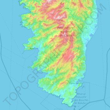
Name: South Corsica topographic map, elevation, terrain.
Location: South Corsica, Corsica, Metropolitan France, France (41.33319 8.53472 42.38227 9.40799)
Average elevation: 271 m
Minimum elevation: -5 m
Maximum elevation: 2,614 m
Other topographic maps
Click on a map to view its topography, its elevation and its terrain.