
County Limerick topographic map
Interactive map
Click on the map to display elevation.
About this map
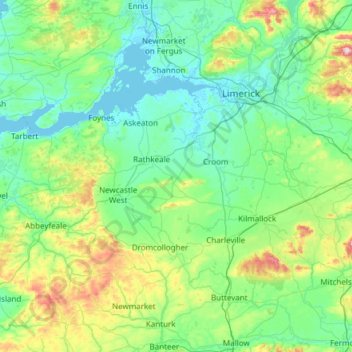
Name: County Limerick topographic map, elevation, terrain.
Location: County Limerick, Munster, Ireland (52.28020 -9.36543 52.69629 -8.15637)
Average elevation: 107 m
Minimum elevation: -2 m
Maximum elevation: 688 m
One possible meaning for the county's name in Irish Luimneach is "the flat area"; this description is accurate as the land consists mostly of a fertile limestone plain. Moreover, the county is ringed by mountains: the Slieve Felims to the northeast, the Galtees to the southeast, the Ballyhoura Mountains to the south, and the Mullaghareirk Mountains to the southwest and west. The highest point in the county is located in its south-east corner at Galtymore (919 m), which separates Limerick from County Tipperary. Limerick shares the 3rd-highest county peak in Ireland with Tipperary. The county is not a simply a plain, its topography consists of hills and ridges. The eastern part of the county is part of the Golden Vale, which is well known for dairy produce and consists of rolling low hills. This gives way to very flat land around the centre of the county, with the exception being Knockfierna at 288 m high. Towards the west, the Mullaghareirk Mountains (Mullach an Radhairc in Irish, roughly meaning "mountains of the view") push across the county offering extensive views east over the county and west into County Kerry.
Other topographic maps
Click on a map to view its topography, its elevation and its terrain.
Newfarm
Newfarm, The Rower, The Municipal District of Callan — Thomastown, County Kilkenny, Leinster, Ireland
Average elevation: 33 m
Blanchardstown
Blanchardstown, Fingal, County Dublin, Leinster, D15 KPW7, Ireland
Average elevation: 61 m
Rathmines
Ireland > County Dublin > Dublin
Rathmines, Rathmines West B Ward 1986, Dublin, County Dublin, Leinster, Ireland
Average elevation: 28 m
Louisburgh
Louisburgh, Westport-Belmullet Municipal District, County Mayo, Connacht, Ireland
Average elevation: 17 m
Ballina
Ballina, Ballina Municipal District, County Mayo, Connacht, Ireland
Average elevation: 19 m
Gunpoint
Gunpoint, Lowertown, West Cork, County Cork, Munster, Ireland
Average elevation: 14 m
Killarney
Killarney, Killarney Municipal District, County Kerry, Munster, Ireland
Average elevation: 57 m
Newbridge
Newbridge, The Municipal District of Kildare — Newbridge, County Kildare, Leinster, Ireland
Average elevation: 95 m
Ballyboden
Ballyboden, South Dublin, County Dublin, Leinster, D14 VY33, Ireland
Average elevation: 83 m
Took
Took, Modelligo, The Municipal District of Dungarvan — Lismore, County Waterford, Munster, Ireland
Average elevation: 169 m
Dún Laoghaire
Dún Laoghaire, Dún Laoghaire-Rathdown, County Dublin, Leinster, A96 T860, Ireland
Average elevation: 21 m
Powderly Lower
Ireland > County Donegal > Kildoney
Powderly Lower, Kildoney, Castlefinn ED, Lifford-Stranorlar Municipal District, County Donegal, Ulster, Ireland
Average elevation: 57 m
Thomastown
Thomastown, The Municipal District of Callan — Thomastown, County Kilkenny, Leinster, Ireland
Average elevation: 44 m
Waterfall
Waterfall, Inishkenny, Municipal District of Carrigaline, County Cork, Munster, T12 CYF2, Ireland
Average elevation: 96 m
Moyle Beg
Moyle Beg, Cormeen ED, Ballybay-Clones Municipal District, County Monaghan, Ulster, Ireland
Average elevation: 135 m
Carlingford
Carlingford, County Louth, Leinster, Ireland
Average elevation: 84 m
Saint Kevins Ward 1986
Ireland > County Dublin > Dublin
Saint Kevins Ward 1986, Dublin, County Dublin, Leinster, Ireland
Average elevation: 18 m
Letterkenny
Letterkenny, County Donegal, Ulster, Ireland
Average elevation: 92 m
Camira Glebe
Camira Glebe, Rosenallis ED, The Municipal District of Borris-in-Ossory — Mountmellick, County Laois, Leinster, Ireland
Average elevation: 82 m
Naas
Naas, The Municipal District of Naas, County Kildare, Leinster, Ireland
Average elevation: 99 m
Kilcullen
Kilcullen, Municipal District of Macroom, County Cork, Munster, Ireland
Average elevation: 216 m
Dunmore
Dunmore, Tuam Municipal District, County Galway, Connacht, Ireland
Average elevation: 63 m
Jerpoint Church
Jerpoint Church, The Municipal District of Callan — Thomastown, County Kilkenny, Leinster, Ireland
Average elevation: 94 m
Clara
Clara, Clara ED, The Municipal District of Tullamore, County Offaly, Leinster, Ireland
Average elevation: 62 m
Listowel Municipal District
Listowel Municipal District, County Kerry, Munster, Ireland
Average elevation: 67 m
Cliffs of Moher
Cliffs of Moher, Ballysteen ED, West Clare Municipal District, County Clare, Munster, Ireland
Average elevation: 55 m
The Glen
Ireland > County Cork > Cork
The Glen, Dublin Hill, The Glen B, Cork, County Cork, Munster, T23 D437, Ireland
Average elevation: 57 m
Holycross
Holycross, The Municipal District of Thurles, County Tipperary, Munster, Ireland
Average elevation: 99 m
The Municipal District of Greystones
The Municipal District of Greystones, County Wicklow, Leinster, Ireland
Average elevation: 89 m
The Municipal District of Bray
The Municipal District of Bray, County Wicklow, Leinster, Ireland
Average elevation: 283 m
Athenry-Oranmore Municipal District
Athenry-Oranmore Municipal District, County Galway, Connacht, Ireland
Average elevation: 42 m
Killaloe Municipal District
Killaloe Municipal District, County Clare, Munster, Ireland
Average elevation: 85 m
Wexford
Wexford, The Borough District of Wexford, County Wexford, Leinster, Ireland
Average elevation: 23 m
Dingle
Dingle, Kenmare Municipal District, County Kerry, Munster, Ireland
Average elevation: 121 m
Connolly
Connolly, Kinturk ED, West Clare Municipal District, County Clare, Munster, Ireland
Average elevation: 96 m
Glenbrook
Ireland > County Cork > Municipal District of Carrigaline
Glenbrook, Municipal District of Carrigaline, County Cork, Munster, T12 KT5N, Ireland
Average elevation: 50 m
Mother Mountain
Mother Mountain, The Municipal District of Nenagh, County Tipperary, Munster, Ireland
Average elevation: 368 m
Ballymacarbry
Ballymacarbry, The Municipal District of Comeragh, County Waterford, Munster, Ireland
Average elevation: 145 m
Kilkenny
Kilkenny, County Kilkenny, Leinster, Ireland
Average elevation: 62 m
Ruan
Ruan, West Clare Municipal District, County Clare, Munster, Ireland
Average elevation: 22 m
Collinstown
Collinstown, Airport ED, Fingal, County Dublin, Leinster, Ireland
Average elevation: 62 m