
Cape Canaveral topographic map
Interactive map
Click on the map to display elevation.
About this map
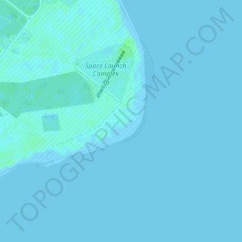
Name: Cape Canaveral topographic map, elevation, terrain.
Location: Cape Canaveral, Brevard County, Florida, United States (28.44077 -80.53662 28.46077 -80.51662)
Average elevation: 1 m
Minimum elevation: -2 m
Maximum elevation: 8 m
The hurricane of August 1885, pushed a "wall of water" over the barrier island (elevation, 3.1 m (10 ft)) devastating Cape Canaveral and adjacent areas. The ocean waves flooded the homesteaders and discouraged further settlement in the area. The beach near the lighthouse was severely eroded prompting its relocation 1.6 km (0.99 mi) west inland.
Other topographic maps
Click on a map to view its topography, its elevation and its terrain.
Micco
United States > Florida > Brevard County
Micco, Brevard County, Florida, 32976, United States
Average elevation: 6 m
Melbourne
United States > Florida > Brevard County > Melbourne
Melbourne, Brevard County, Florida, 32910, United States
Average elevation: 4 m
Malabar
United States > Florida > Brevard County
Malabar, Brevard County, Florida, 32950, United States
Average elevation: 7 m
West Melbourne
United States > Florida > Brevard County
West Melbourne, Brevard County, Florida, 32904, United States
Average elevation: 10 m
Melbourne
United States > Florida > Brevard County > Melbourne
Melbourne, Brevard County, Florida, United States
Average elevation: 6 m
Melbourne
United States > Florida > Brevard County
Melbourne, Brevard County, Florida, United States
Average elevation: 6 m