
Pennine Alps topographic map
Interactive map
Click on the map to display elevation.
About this map
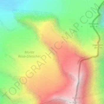
Name: Pennine Alps topographic map, elevation, terrain.
Location: Pennine Alps, Zermatt, Visp, Valais/Wallis, 3920, Switzerland (45.94995 7.85995 45.95005 7.86005)
Average elevation: 3,842 m
Minimum elevation: 3,149 m
Maximum elevation: 4,619 m
Other topographic maps
Click on a map to view its topography, its elevation and its terrain.
Zumsteinspitze
Switzerland > Valais/Wallis > Zermatt
Zumsteinspitze, Zermatt, Visp, Valais/Wallis, 3920, Switzerland
Average elevation: 4,001 m
Stockhorn
Switzerland > Valais/Wallis > Zermatt
Stockhorn, Zermatt, Visp, Valais/Wallis, 3920, Switzerland
Average elevation: 3,006 m
Ober Gabelhorn
Switzerland > Valais/Wallis > Zermatt
Ober Gabelhorn, Zermatt, Visp, Valais/Wallis, 3920, Switzerland
Average elevation: 3,320 m
Dunantspitze
Switzerland > Valais/Wallis > Zermatt
Dunantspitze, Zermatt, Visp, Valais/Wallis, 3920, Switzerland
Average elevation: 4,017 m
Dufourspitze (Monte Rosa)
Switzerland > Valais/Wallis > Zermatt
Dufourspitze (Monte Rosa), Zermatt, Visp, Valais/Wallis, 3920, Switzerland
Average elevation: 4,033 m
Gornergrat
Switzerland > Valais/Wallis > Zermatt
Gornergrat, Hohtälli, Ze Seewjinen, Zermatt, Visp, Valais/Wallis, 3920, Switzerland
Average elevation: 2,768 m