
Nagercoil topographic map
Interactive map
Click on the map to display elevation.
About this map
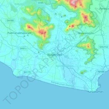
Name: Nagercoil topographic map, elevation, terrain.
Average elevation: 83 m
Minimum elevation: -1 m
Maximum elevation: 1,304 m
Other topographic maps
Click on a map to view its topography, its elevation and its terrain.
Manakudy
India > Tamil Nadu > Agastheeswaram
Manakudy, Agastheeswaram, Kanniyakumari District, Tamil Nadu, 629602, India
Average elevation: 6 m
Karavilai
India > Tamil Nadu > Agastheeswaram
Karavilai, Agastheeswaram, Kanniyakumari District, Tamil Nadu, 629503, India
Average elevation: 28 m
Kanyakumari
India > Tamil Nadu > Agastheeswaram
Kanyakumari, Agastheeswaram, Kanniyakumari District, Tamil Nadu, 629702, India
Average elevation: 6 m