
Sofala Province topographic map
Interactive map
Click on the map to display elevation.
About this map
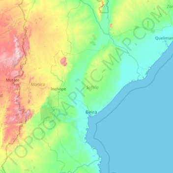
Name: Sofala Province topographic map, elevation, terrain.
Location: Sofala Province, Mozambique (-21.31684 33.38137 -16.80136 36.19341)
Average elevation: 268 m
Minimum elevation: -1 m
Maximum elevation: 2,489 m
Gorongosa National Park, at the southern end of the Great African Rift Valley, covers several thousand square kilometres, including the valley floor and parts of surrounding forested plateaus, which contain miombo and montane forests. The park contains the 1,863 metres (6,112 ft) Mount Gorongosa, a mountain which is considered sacred to the people of the country. On the eastern slope of the mountain is a number of vegetation zones according to elevation, and there are numerous limestone caves in the vicinity.
Other topographic maps
Click on a map to view its topography, its elevation and its terrain.
Negomano
Mozambique > Cabo Delgado Province
Negomano, Mueda, Cabo Delgado Province, Mozambique
Average elevation: 151 m
Nacala
Nacala, Nampula Province, 3112, Mozambique
Average elevation: 45 m
Cabo Delgado Province
Cabo Delgado Province, Zona Norte, Mozambique
Average elevation: 261 m
Nova Zambézia
Mozambique > Cabo Delgado > Nova Zambézia
Nova Zambézia, Cabo Delgado, Mozambique
Average elevation: 211 m