
Coles Bay topographic map
Interactive map
Click on the map to display elevation.
About this map
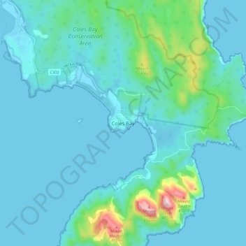
Name: Coles Bay topographic map, elevation, terrain.
Location: Coles Bay, Tasmania, 7251, Australia (-42.16522 148.24854 -42.08522 148.32854)
Average elevation: 57 m
Minimum elevation: -1 m
Maximum elevation: 476 m
Other topographic maps
Click on a map to view its topography, its elevation and its terrain.
Wineglass Bay
Australia > Tasmania > Coles Bay
Wineglass Bay, Isthmus Track, Coles Bay, Tasmania, 7251, Australia
Average elevation: 45 m