
Reefton topographic map
Interactive map
Click on the map to display elevation.
About this map
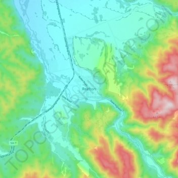
Name: Reefton topographic map, elevation, terrain.
Location: Reefton, Buller District, West Coast, 7830, New Zealand (-42.15594 171.82346 -42.07594 171.90346)
Average elevation: 310 m
Minimum elevation: 156 m
Maximum elevation: 713 m
Located in the Inangahua Valley at an altitude of 194m, Reefton falls under the Köppen-Geiger climate classification of Cfb (Oceanic). At an average temperature of 15.9 °C, February is the warmest month. July is the coldest month, at 6.8 °C. Reefton's average annual temperature is 11.4 °C. On average, snowfall occurs on 1.4 days annually, and an average of 22.1 days per year will exceed 26.7 °C (80 °F). During an average winter, Reefton can expect to see 47 days of frost.
Other topographic maps
Click on a map to view its topography, its elevation and its terrain.
Mount Baldy
New Zealand > West Coast > Buller District
Mount Baldy, Buller District, West Coast, New Zealand
Average elevation: 1,059 m
Westport
New Zealand > West Coast > Buller District > Westport
Westport, Buller District, West Coast, 7825, New Zealand
Average elevation: 13 m