
Highgate Hill topographic map
Interactive map
Click on the map to display elevation.
About this map
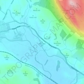
Name: Highgate Hill topographic map, elevation, terrain.
Average elevation: 141 m
Minimum elevation: 97 m
Maximum elevation: 349 m
Other topographic maps
Click on a map to view its topography, its elevation and its terrain.
Ingleton
United Kingdom > England > Craven > Ingleton
Ingleton, Craven, North Yorkshire, Yorkshire and the Humber, England, LA6 3FX, United Kingdom
Average elevation: 185 m
Craven
United Kingdom > England > Craven
Craven, North Yorkshire, Yorkshire and the Humber, England, United Kingdom
Average elevation: 294 m
Arncliffe
United Kingdom > England > Craven
Arncliffe, Craven, North Yorkshire, Yorkshire and the Humber, England, United Kingdom
Average elevation: 396 m
Robin Hill
United Kingdom > England > Craven
Robin Hill, Craven, North Yorkshire, Yorkshire and the Humber, England, BD23 3PR, United Kingdom
Average elevation: 147 m
Ward Hill
United Kingdom > England > Craven
Ward Hill, Craven, North Yorkshire, Yorkshire and the Humber, England, LS29 0RH, United Kingdom
Average elevation: 164 m