
Lund topographic map
Interactive map
Click on the map to display elevation.
About this map
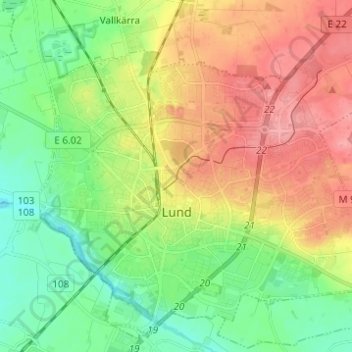
Name: Lund topographic map, elevation, terrain.
Location: Lund, Lund Municipality, Skåne County, Sweden (55.67839 13.14017 55.74129 13.26341)
Average elevation: 42 m
Minimum elevation: 6 m
Maximum elevation: 88 m
Other topographic maps
Click on a map to view its topography, its elevation and its terrain.
Östra Torn
Sweden > Skåne County > Lund
Östra Torn, Öster, Lund, Lund Municipality, Skåne County, Sweden
Average elevation: 71 m