
Shenyang City topographic map
Interactive map
Click on the map to display elevation.
About this map
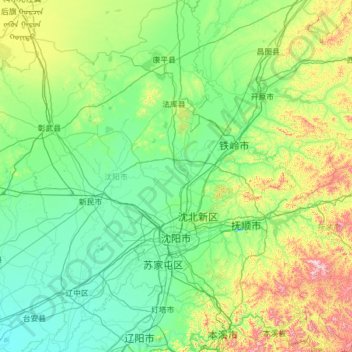
Name: Shenyang City topographic map, elevation, terrain.
Location: Shenyang City, Liaoning, China (41.19769 122.41674 43.04030 123.80854)
Average elevation: 155 m
Minimum elevation: 3 m
Maximum elevation: 1,101 m
Shenyang ranges in latitude from 41° 11' to 43° 02' N and in longitude from 122° 25' to 123° 48' E, and is located in the central part of Liaoning province. The western parts of the city's administrative area are located on the alluvial plain of the Liao River system, while the eastern part consists of the hinterlands of the Changbai Mountains, and is covered with forests. The highest point in Shenyang is 414 m (1,358 ft) above sea level and the lowest point only 7 m (23 ft). The average elevation of the urban area is 45 m (148 ft).
Other topographic maps
Click on a map to view its topography, its elevation and its terrain.
Taiping District
Taiping District, Fuxin City, Liaoning, 123000, China
Average elevation: 235 m
Dalian
China > Liaoning > Dalian > Qingniwaqiao Subdistrict
Dalian, Qingniwaqiao Subdistrict, Zhongshan District, Dalian City, Liaoning, 116011, China
Average elevation: 27 m