
Loiret topographic map
Interactive map
Click on the map to display elevation.
About this map
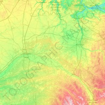
Name: Loiret topographic map, elevation, terrain.
Location: Loiret, Centre-Val de Loire, Metropolitan France, France (47.48306 1.51220 48.34495 3.12864)
Average elevation: 135 m
Minimum elevation: 43 m
Maximum elevation: 361 m
Other topographic maps
Click on a map to view its topography, its elevation and its terrain.
Dreux
France > Centre-Val de Loire > Eure-et-Loir
Dreux, Eure-et-Loir, Centre-Val de Loire, Metropolitan France, 28100, France
Average elevation: 113 m
Cher
Cher, Centre-Val de Loire, Metropolitan France, France
Average elevation: 207 m
L'Esperance
France > Centre-Val de Loire > Indre-et-Loire > Nouzilly
L'Esperance, Nouzilly, Loches, Indre-et-Loire, Centre-Val de Loire, Metropolitan France, 37380, France
Average elevation: 115 m
Loches
France > Centre-Val de Loire > Indre-et-Loire
Loches, Indre-et-Loire, Centre-Val de Loire, Metropolitan France, 37600, France
Average elevation: 106 m
Tours
France > Centre-Val de Loire > Indre-et-Loire
Tours, Arrondissement de Tours, Indre-et-Loire, Centre-Val de Loire, Metropolitan France, France
Average elevation: 73 m
Mardié
France > Centre-Val de Loire > Loiret
Mardié, Orléans, Loiret, Centre-Val de Loire, Metropolitan France, 45430, France
Average elevation: 110 m