
Bicker Isles topographic map
Interactive map
Click on the map to display elevation.
About this map
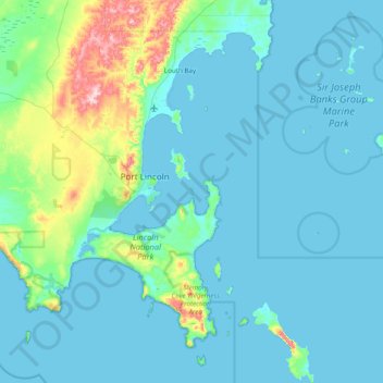
Name: Bicker Isles topographic map, elevation, terrain.
Location: Bicker Isles, Port Lincoln, South Australia, Australia (-35.06549 135.63503 -34.42549 136.27503)
Average elevation: 31 m
Minimum elevation: -1 m
Maximum elevation: 283 m
Other topographic maps
Click on a map to view its topography, its elevation and its terrain.
Port Lincoln
Australia > South Australia > Port Lincoln
Port Lincoln, City of Port Lincoln, South Australia, 5606, Australia
Average elevation: 49 m
Grantham Island
Australia > South Australia > Port Lincoln
Grantham Island, Port Lincoln, South Australia, Australia
Average elevation: 2 m