
Redding topographic map
Interactive map
Click on the map to display elevation.
About this map
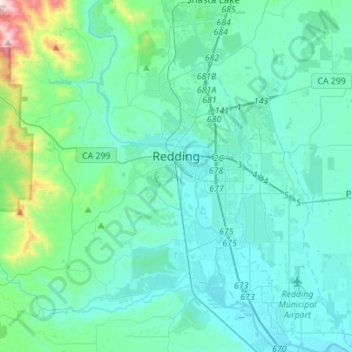
Name: Redding topographic map, elevation, terrain.
Location: Redding, Shasta County, California, United States (40.46892 -122.45386 40.67950 -122.27359)
Average elevation: 240 m
Minimum elevation: 118 m
Maximum elevation: 1,078 m
Other topographic maps
Click on a map to view its topography, its elevation and its terrain.
Old Station
United States > California > Shasta County > Old Station
Old Station, Shasta County, California, 96071, United States
Average elevation: 1,383 m