
Chichester topographic map
Interactive map
Click on the map to display elevation.
About this map
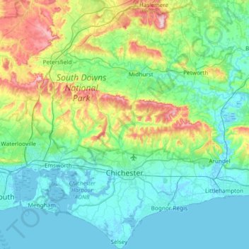
Name: Chichester topographic map, elevation, terrain.
Location: Chichester, West Sussex, South East, England, United Kingdom (50.72203 -0.95760 51.09449 -0.47318)
Average elevation: 57 m
Minimum elevation: -4 m
Maximum elevation: 279 m
Other topographic maps
Click on a map to view its topography, its elevation and its terrain.
Fernhurst
United Kingdom > England > Chichester
Fernhurst, Chichester, West Sussex, South East, England, United Kingdom
Average elevation: 123 m