
Stafford topographic map
Interactive map
Click on the map to display elevation.
About this map
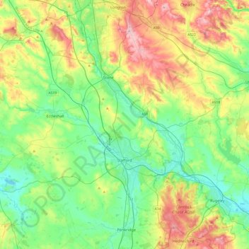
Name: Stafford topographic map, elevation, terrain.
Location: Stafford, Staffordshire, England, United Kingdom (52.71503 -2.41635 52.98056 -1.93333)
Average elevation: 127 m
Minimum elevation: 63 m
Maximum elevation: 256 m
Other topographic maps
Click on a map to view its topography, its elevation and its terrain.
Brown Lees Rec
United Kingdom > England > Staffordshire > Staffordshire Moorlands > Biddulph
Brown Lees Rec, Brown Lees, Biddulph, Staffordshire Moorlands, Staffordshire, England, United Kingdom
Average elevation: 210 m
Chasewater
United Kingdom > England > Staffordshire > Lichfield > Burntwood > Chasetown
Chasewater, Burntwood, Chasetown, Lichfield, Staffordshire, England, WS8 7NL, United Kingdom
Average elevation: 155 m
Leyfields
United Kingdom > England > Staffordshire > Tamworth > Leyfields
Leyfields, Tamworth, Staffordshire, England, B79 8HS, United Kingdom
Average elevation: 66 m
Leek
United Kingdom > England > Staffordshire > Staffordshire Moorlands > Leek
Leek, Staffordshire Moorlands, Staffordshire, West Midlands, England, United Kingdom
Average elevation: 193 m
Staffordshire
United Kingdom > England > Staffordshire
Staffordshire, West Midlands, England, United Kingdom
Average elevation: 130 m