
Grose River topographic map
Interactive map
Click on the map to display elevation.
About this map
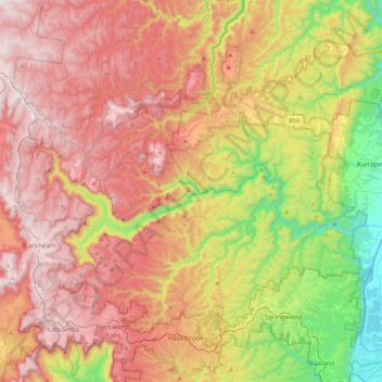
Name: Grose River topographic map, elevation, terrain.
Average elevation: 589 m
Minimum elevation: 5 m
Maximum elevation: 1,121 m
Other topographic maps
Click on a map to view its topography, its elevation and its terrain.
Grose Valley
Australia > New South Wales > Bell
Grose Valley, Bell, Blue Mountains City Council, New South Wales, 2786, Australia
Average elevation: 833 m