
Hereford topographic map
Interactive map
Click on the map to display elevation.
About this map
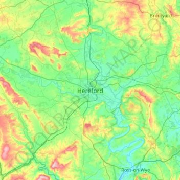
Name: Hereford topographic map, elevation, terrain.
Average elevation: 109 m
Minimum elevation: 29 m
Maximum elevation: 357 m
Other topographic maps
Click on a map to view its topography, its elevation and its terrain.
Gloucestershire
United Kingdom > England > Hereford
Gloucestershire, Twyford Road, Rotherwas Industrial Estate, Lower Bullingham, Hereford, Herefordshire, West Midlands, England, HR2 6NP, United Kingdom
Average elevation: 104 m