
Chaniotis topographic map
Interactive map
Click on the map to display elevation.
About this map
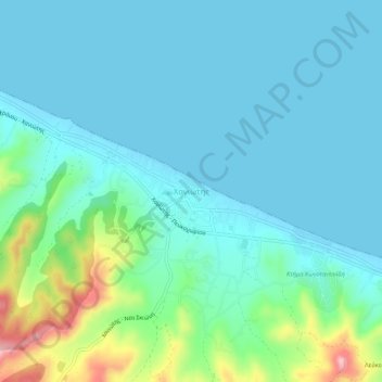
Name: Chaniotis topographic map, elevation, terrain.
Average elevation: 36 m
Minimum elevation: 0 m
Maximum elevation: 194 m
Chaniotis (Greek: Χανιώτης, Chaniótis or Χανιώτη, Chanióti), is a tourist town located in the eastern part of the peninsula of Kassandra, Chalkidiki, Greece. The population in 2011 was 893, the elevation is 10 m. The population during the summer increases many times. Chanioti is situated on the northeastern coast of the peninsula, 3 km northwest of Pefkochori, 4 km southeast of Polychrono, 7 km northeast of Nea Skioni and 89 km southeast of Thessaloniki. There are forests in the mountains near Chaniotis, and farmlands along the coast. The beach of Chaniotis attracts many tourists.