
Arthur's Seat topographic map
Interactive map
Click on the map to display elevation.
About this map
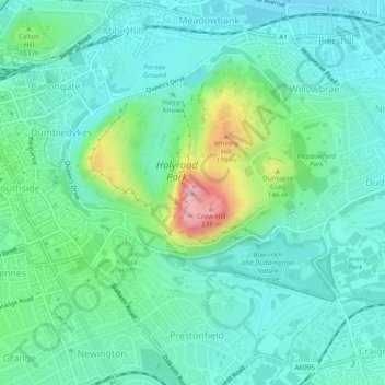
Name: Arthur's Seat topographic map, elevation, terrain.
Average elevation: 69 m
Minimum elevation: 18 m
Maximum elevation: 239 m
Other topographic maps
Click on a map to view its topography, its elevation and its terrain.
Middle Norton
United Kingdom > Scotland > City of Edinburgh > Ratho Station
Middle Norton, Ratho Station, City of Edinburgh, Scotland, EH28 8NA, United Kingdom
Average elevation: 52 m