
Ayer's Cliff topographic map
Interactive map
Click on the map to display elevation.
About this map
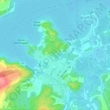
Name: Ayer's Cliff topographic map, elevation, terrain.
Location: Ayer's Cliff, Memphrémagog, Estrie, Quebec, Canada (45.16050 -72.07353 45.19009 -72.03218)
Average elevation: 171 m
Minimum elevation: 158 m
Maximum elevation: 242 m
Other topographic maps
Click on a map to view its topography, its elevation and its terrain.
Magog
Canada > Quebec > Memphrémagog
Magog, Memphrémagog, Estrie, Quebec, Canada
Average elevation: 250 m