
Marble Hill topographic map
Interactive map
Click on the map to display elevation.
About this map
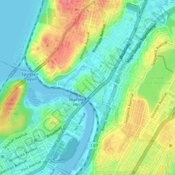
Name: Marble Hill topographic map, elevation, terrain.
Location: Marble Hill, New York, United States of America (40.87140 -73.91838 40.88045 -73.90616)
Average elevation: 27 m
Minimum elevation: 0 m
Maximum elevation: 75 m
Because of this change in topography, Marble Hill is often associated with the Bronx and is part of Bronx Community District 8. In addition, Marble Hill has a Bronx ZIP Code of 10463, and is served by the New York City Police Department's 50th Precinct, headquartered in the Bronx.
Other topographic maps
Click on a map to view its topography, its elevation and its terrain.
Wave Hill
United States of America > New York > New York
Wave Hill, Riverdale, New York, The Bronx, Bronx County, New York, United States of America
Average elevation: 25 m
WNYC-AM (New York)
United States of America > New York > New York
WNYC-AM (New York), 8, Greenpoint Avenue, Greenpoint, New York, Brooklyn, Kings County, New York, 11222, United States of America
Average elevation: 4 m
Liggett Terrace
United States of America > New York > New York > Liggett Terrace
Liggett Terrace, Manhattan Community Board 1, Manhattan, New York County, New York, 10004, United States of America
Average elevation: 3 m