
Kyiv topographic map
Interactive map
Click on the map to display elevation.
Kyiv
Originally on the west bank, today Kyiv is on both sides of the Dnieper, which flows southwards through the city towards the Black Sea. The older and higher western part of the city sits on numerous wooded hills (Kyiv Hills), with ravines and small rivers. Kyiv's geographical relief contributed to its toponyms, such as Podil ("lower"), Pechersk ("caves"), and uzviz (a steep street, "descent"). Kyiv is a part of the larger Dnieper Upland adjoining the western bank of the Dnieper in its mid-flow, and which contributes to the city's elevation change.
About this map
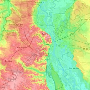
Name: Kyiv topographic map, elevation, terrain.
Location: Kyiv, Ukraine (50.21324 30.23615 50.59081 30.82636)
Average elevation: 133 m
Minimum elevation: 86 m
Maximum elevation: 210 m
Other topographic maps
Click on a map to view its topography, its elevation and its terrain.
Krasnogorka
Ukraine > Autonomous Republic of Crimea > Керченський район > Красногорское сельское поселение
Average elevation: 60 m
Kirovo
Ukraine > Autonomous Republic of Crimea > Керченський район > Кировское сельское поселение
Average elevation: 88 m
Hoverla
In the 20th century, the mountain increasingly gained popularity as an extreme sports site. Some routes are classified as 1A in the winter period (from late autumn to May), according to the Soviet grading system. The most popular approach to the summit starts from the tour-basa Zarosliak on the mountain's…
Average elevation: 1,667 m
Dnieper River
The source of the Dnieper is the sedge bogs (Akseninsky Mokh) of the Valdai Hills in central Russia, at an elevation of 220 m (720 ft). For 115 km (71 mi) of its length, it serves as the border between Belarus and Ukraine. Its estuary, or liman, used to be defended by the strong fortress of Ochakiv.
Average elevation: 83 m
Dnipro
The source of the Dnieper is the sedge bogs (Akseninsky Mokh) of the Valdai Hills in central Russia, at an elevation of 220 m (720 ft). For 115 km (71 mi) of its length, it serves as the border between Belarus and Ukraine. Its estuary, or liman, used to be defended by the strong fortress of Ochakiv.
Average elevation: 110 m
Zhuravli
Ukraine > Autonomous Republic of Crimea > Євпаторійський район > Митяевское сельское поселение
Average elevation: 14 m
Туркмен
Ukraine > Autonomous Republic of Crimea > Lenine Raion > Октябрьское сельское поселение
Average elevation: 93 m
Vodiane
Ukraine > Dnipropetrovsk Oblast
Vodiane or Vodyane (Ukrainian: Водяне) is a village in Pokrovsk Raion, Donetsk Oblast, Ukraine. In 2001, the population was 319 and the elevation is 177m. Up until 2020, the village was part of Yasynuvata Raion, until it was merged into Pokrovsk Raion.
Average elevation: 147 m