Geolocate

Doonan topographic map

Interactive map

Click on the map to display elevation.

About this map

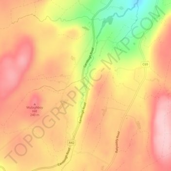
Name: Doonan topographic map, elevation, terrain.

Location: Doonan, Northern Ireland, United Kingdom (54.93960 -6.03839 54.96561 -6.00132)

Average elevation: 186 m

Minimum elevation: 56 m

Maximum elevation: 260 m

Other topographic maps

Click on a map to view its topography, its elevation and its terrain.

Randalstown

United Kingdom > Northern Ireland > County Antrim

Randalstown, County Antrim, Northern Ireland, BT41 3AD, United Kingdom

Average elevation: 57 m

Larne

United Kingdom > Northern Ireland > County Antrim

Larne, County Antrim, Northern Ireland, BT40 1JS, United Kingdom

Average elevation: 54 m

Hillhall

United Kingdom > Northern Ireland > County Down

Hillhall, County Down, Northern Ireland, BT27 5JA, United Kingdom

Average elevation: 61 m

Belfast

United Kingdom > Northern Ireland > County Antrim

Belfast, County Antrim, Northern Ireland, United Kingdom

Average elevation: 92 m

Tandragee

United Kingdom > Northern Ireland > County Armagh

Tandragee, County Armagh, Ulster, Northern Ireland, BT62 2DG, United Kingdom

Average elevation: 50 m

County Tyrone

United Kingdom > Northern Ireland

County Tyrone, Ulster, Northern Ireland, United Kingdom

Average elevation: 128 m

Carrickfergus

United Kingdom > Northern Ireland > County Antrim

Carrickfergus, County Antrim, Ulster, Northern Ireland, BT38 7AF, United Kingdom

Average elevation: 49 m

Benraw

United Kingdom > Northern Ireland > County Down

Benraw, County Down, Ulster, Northern Ireland, United Kingdom

Average elevation: 182 m

Armagh

United Kingdom > Northern Ireland > County Armagh > Milford

Armagh, Milford, County Armagh, Ulster, Northern Ireland, United Kingdom

Average elevation: 100 m

Newry

United Kingdom > Northern Ireland > County Down

Newry, County Down, Northern Ireland, United Kingdom

Average elevation: 73 m

Backwood

United Kingdom > Northern Ireland

Backwood, Ulster, Northern Ireland, United Kingdom

Average elevation: 81 m

Blaney

United Kingdom > Northern Ireland

Blaney, Blaney East, Fermanagh and Omagh District, Northern Ireland, United Kingdom

Average elevation: 84 m

Ulster

United Kingdom > Northern Ireland

Ulster, Northern Ireland, United Kingdom

Average elevation: 71 m

Banbridge

United Kingdom > Northern Ireland > County Down

Banbridge, County Down, Northern Ireland, BT32 3DB, United Kingdom

Average elevation: 90 m

Belcoo

United Kingdom > Northern Ireland > County Fermanagh > Belcoo

Belcoo, County Fermanagh, Northern Ireland, BT93 5FB, United Kingdom

Average elevation: 86 m

Pig Island

United Kingdom > Northern Ireland

Pig Island, Northern Ireland, United Kingdom

Average elevation: 8 m

Antrim

United Kingdom > Northern Ireland > County Antrim > Antrim

Antrim, County Antrim, Northern Ireland, BT41 4AR, United Kingdom

Average elevation: 50 m

Lough Neagh

United Kingdom > Northern Ireland > Lisburn

Lough Neagh, Lisburn, County Antrim, Northern Ireland, United Kingdom

Average elevation: 29 m

Boho

United Kingdom > Northern Ireland > County Fermanagh

Boho, County Fermanagh, Northern Ireland, BT74 8BZ, United Kingdom

Average elevation: 102 m

Moneyscalp

United Kingdom > Northern Ireland

Moneyscalp, Northern Ireland, United Kingdom

Average elevation: 147 m

Carryduff

United Kingdom > Northern Ireland > County Down > Carryduff

Carryduff, County Down, Northern Ireland, BT8 8DN, United Kingdom

Average elevation: 110 m

Spring Farm

United Kingdom > Northern Ireland

Spring Farm, Northern Ireland, United Kingdom

Average elevation: 42 m

Ballymena

United Kingdom > Northern Ireland > County Antrim > Ballymena

Ballymena, County Antrim, Northern Ireland, BT43 6AH, United Kingdom

Average elevation: 74 m

Stoneyford

United Kingdom > Northern Ireland > Lisburn > Stoneyford

Stoneyford, Lisburn, County Antrim, Northern Ireland, BT28 3SU, United Kingdom

Average elevation: 159 m

Old Mill

United Kingdom > Northern Ireland > County Antrim > Ballygally > Old Mill

Old Mill, Ballygally, County Antrim, Northern Ireland, BT40 2RX, United Kingdom

Average elevation: 47 m

Comber

United Kingdom > Northern Ireland > Comber

Comber, County Down, Northern Ireland, BT23 5DZ, United Kingdom

Average elevation: 36 m

Dungannon

United Kingdom > Northern Ireland > Dungannon

Dungannon, County Tyrone, Northern Ireland, BT71 7AA, United Kingdom

Average elevation: 76 m

Bushmills

United Kingdom > Northern Ireland > County Antrim

Bushmills, County Antrim, Ulster, Northern Ireland, BT57 8QB, United Kingdom

Average elevation: 42 m

Ormeau Park

United Kingdom > Northern Ireland

Ormeau Park, Ballynafeigh, County Down, Northern Ireland, United Kingdom

Average elevation: 11 m

Eglinton

United Kingdom > Northern Ireland > Eglinton

Eglinton, County Londonderry, Northern Ireland, BT47 3GY, United Kingdom

Average elevation: 48 m

Malone Lower

United Kingdom > Northern Ireland > Belfast

Malone Lower, Belfast, County Antrim, Northern Ireland, United Kingdom

Average elevation: 15 m

Magherafelt

United Kingdom > Northern Ireland > Magherafelt

Magherafelt, County Londonderry, Northern Ireland, BT45 6EE, United Kingdom

Average elevation: 59 m

Drumanure

United Kingdom > Northern Ireland > Derrygonnelly

Drumanure, Derrygonnelly, County Fermanagh, Northern Ireland, United Kingdom

Average elevation: 67 m

British

United Kingdom > Northern Ireland > Aldergrove

British, Aldergrove, County Antrim, Northern Ireland, BT29 4ZY, United Kingdom

Average elevation: 58 m

Annaghboy

United Kingdom > Northern Ireland > Armagh

Annaghboy, Armagh, County Armagh, Northern Ireland, United Kingdom

Average elevation: 54 m

Rostrevor

United Kingdom > Northern Ireland > Rostrevor

Rostrevor, County Down, Northern Ireland, United Kingdom

Average elevation: 78 m

Trial Bay

United Kingdom > Northern Ireland

Trial Bay, County Fermanagh, Northern Ireland, BT92 9GN, United Kingdom

Average elevation: 50 m

Ballykeel

United Kingdom > Northern Ireland > Ballymena

Ballykeel, Ballymena, County Antrim, Northern Ireland, United Kingdom

Average elevation: 58 m

Ballygawley

United Kingdom > Northern Ireland

Ballygawley, County Londonderry, Northern Ireland, United Kingdom

Average elevation: 40 m

Newry

United Kingdom > Northern Ireland > County Down > Newry

Newry, County Down, Northern Ireland, BT34 1DG, United Kingdom

Average elevation: 129 m

Forth River

United Kingdom > Northern Ireland > Belfast

Forth River, Belfast, County Antrim, Northern Ireland, BT13 3BU, United Kingdom

Average elevation: 73 m

Loughinisland

United Kingdom > Northern Ireland > Loughinisland

Loughinisland, County Down, Northern Ireland, BT24 8RL, United Kingdom

Average elevation: 50 m

County Down

United Kingdom > Northern Ireland

County Down, Northern Ireland, United Kingdom

Average elevation: 65 m

Lisburn

United Kingdom > Northern Ireland > County Antrim

Lisburn, County Antrim, Northern Ireland, BT28 1BJ, United Kingdom

Average elevation: 92 m

Black Mountain

United Kingdom > Northern Ireland > Lisburn

Black Mountain, Lisburn, County Antrim, Northern Ireland, BT11 8BU, United Kingdom

Average elevation: 232 m

Seaforde

United Kingdom > Northern Ireland > Clough

Seaforde, Clough, County Down, Northern Ireland, BT30 8RE, United Kingdom

Average elevation: 34 m

Roe

United Kingdom > Northern Ireland > Londonderry/Derry

Roe, Londonderry/Derry, County Londonderry, Northern Ireland, BT47 4LG, United Kingdom

Average elevation: 83 m

Lisdrumgullion

United Kingdom > Northern Ireland > Newry

Lisdrumgullion, Newry, County Down, Northern Ireland, BT35 6BH, United Kingdom

Average elevation: 41 m

Mourne Mountains West

United Kingdom > Northern Ireland

Mourne Mountains West, County Down, Northern Ireland, United Kingdom

Average elevation: 272 m

Omagh

United Kingdom > Northern Ireland

Omagh, Fermanagh and Omagh District, Northern Ireland, BT78 1BJ, United Kingdom

Average elevation: 97 m