
Rubicon topographic map
Interactive map
Click on the map to display elevation.
Rubicon
With the revival during the 15th century of interest in the topography of ancient Roman Italy, the matter of identifying the Rubicon in the contemporary landscape became a topic of debate among Renaissance humanists. To support the claim of the Pisciatello, a spurious inscription forbidding the passage of an army in the name of the Roman people and Senate, the so-called Sanctio, was placed by a bridge on that river. The Quattrocento humanist Flavio Biondo was deceived by it; the actual inscription is conserved in the Museo Archeologico, Cesena. As the centuries went by, several rivers of the Adriatic coast between Ravenna and Rimini have at times been said to correspond to the ancient Rubicon.
About this map
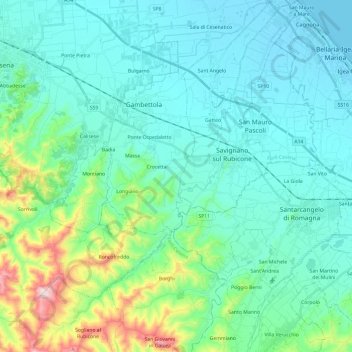
Name: Rubicon topographic map, elevation, terrain.
Location: Rubicon, Forlì-Cesena, Emilia-Romagna, 47043, Italy (43.99541 12.26467 44.16810 12.44337)
Average elevation: 85 m
Minimum elevation: -2 m
Maximum elevation: 474 m
Other topographic maps
Click on a map to view its topography, its elevation and its terrain.