
Lundy topographic map
Interactive map
Click on the map to display elevation.
About this map
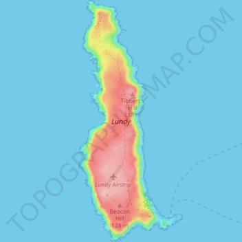
Name: Lundy topographic map, elevation, terrain.
Average elevation: 16 m
Minimum elevation: 0 m
Maximum elevation: 144 m
Other topographic maps
Click on a map to view its topography, its elevation and its terrain.
Appledore
United Kingdom > England > Torridge > Appledore
Appledore, Torridge, Devon, South West England, England, United Kingdom
Average elevation: 14 m
Bideford
United Kingdom > England > Torridge
Bideford, Torridge, Devon, South West England, England, United Kingdom
Average elevation: 56 m