
Cache County topographic map
Interactive map
Click on the map to display elevation.
About this map
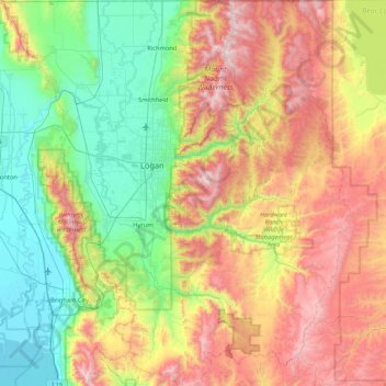
Name: Cache County topographic map, elevation, terrain.
Location: Cache County, Utah, United States (41.36882 -112.16611 41.99955 -111.40158)
Average elevation: 1,906 m
Minimum elevation: 1,279 m
Maximum elevation: 3,003 m
Cache County lies on the north edge of Utah. Its north border abuts the south border of the state of Idaho. On the western edge of the county are the Wellsville Mountains and on the eastern edge are the Bear River Mountains, both northern branches of the Wasatch Range. The Cache Valley reaches north to the state border. The Bear River Mountains, the northernmost extension of the Wasatch Range, cover the eastern half of the county. The county's highest elevation is Naomi Peak in the NE part of the county, at 9,979' (3042m) ASL. The Bear River flows through Cache Valley. The county has a total area of 1,173 square miles (3,040 km2), of which 1,165 square miles (3,020 km2) is land and 8.2 square miles (21 km2) (0.7%) is water.
Other topographic maps
Click on a map to view its topography, its elevation and its terrain.
Sandy
United States > Utah > Salt Lake County
Sandy, Salt Lake County, Utah, United States
Average elevation: 1,376 m
drainage
United States > Utah > Salt Lake County > West Jordan
drainage, West Jordan, Salt Lake County, Utah, United States
Average elevation: 1,389 m
Bayview Heights
United States > Utah > Davis County > Farmington
Bayview Heights, Farmington, Davis County, Utah, 84025, United States
Average elevation: 1,457 m
Virgin
United States > Utah > Washington County
Virgin, Washington County, Utah, United States
Average elevation: 1,251 m
Axtell
United States > Utah > Sanpete County
Axtell, Sanpete County, Utah, 84621, United States
Average elevation: 1,572 m
Park City
United States > Utah > Summit County
Park City, Summit County, Utah, United States
Average elevation: 2,290 m
Kimball Junction
United States > Utah > Summit County
Kimball Junction, Summit County, Utah, 84098, United States
Average elevation: 2,004 m
Bear River
United States > Utah > Rich County
Bear River, Rich County, Utah, 84086, United States
Average elevation: 1,924 m
Salt Lake City
United States > Utah > Salt Lake County > Salt Lake City
Salt Lake City, Salt Lake County, Utah, 84139, United States
Average elevation: 1,625 m
Solitude
United States > Utah > Salt Lake County > Solitude
Solitude, Salt Lake County, Utah, United States
Average elevation: 2,706 m
Paria Canyon
Paria Canyon, Kane County, Utah, United States
Average elevation: 1,581 m
Colorado Plateau
United States > Utah > San Juan County
Colorado Plateau, San Juan County, Utah, United States
Average elevation: 1,512 m
Aquarius Plateau
United States > Utah > Garfield County
Aquarius Plateau, Garfield County, Utah, United States
Average elevation: 3,024 m
Jensen
United States > Utah > Uintah County > Jensen
Jensen, Uintah County, Utah, 84035, United States
Average elevation: 1,470 m
Moab
United States > Utah > Grand County
Moab, Grand County, Utah, 84532, United States
Average elevation: 1,357 m
Midvale
United States > Utah > Midvale
Midvale, Salt Lake County, Utah, 84047, United States
Average elevation: 1,335 m
Farmington Heights
United States > Utah > Farmington > Farmington Heights
Farmington Heights, Farmington, Davis County, Utah, 84025, United States
Average elevation: 1,511 m
Paria River
Paria River, Kane County, Utah, 84718, United States
Average elevation: 1,802 m
West Jordan
United States > Utah > West Jordan
West Jordan, Salt Lake County, Utah, United States
Average elevation: 1,372 m
Salt Lake City
United States > Utah > Salt Lake County
Salt Lake City, Salt Lake County, Utah, United States
Average elevation: 1,592 m
Zion National Park
United States > Utah > Washington County
Zion National Park, Washington County, Utah, United States
Average elevation: 1,877 m
Mount Nebo
United States > Utah > Juab County
Mount Nebo, Juab County, Utah, United States
Average elevation: 3,115 m
South Jordan
United States > Utah > South Jordan
South Jordan, Salt Lake County, Utah, United States
Average elevation: 1,383 m
Provo
United States > Utah > Utah County
Provo, Utah County, Utah, United States
Average elevation: 1,728 m
Saint George
United States > Utah > Washington County
Saint George, Washington County, Utah, United States
Average elevation: 929 m
Mount Magog
United States > Utah > Cache County
Mount Magog, Cache County, Utah, United States
Average elevation: 2,710 m