
Guatemala City topographic map
Interactive map
Click on the map to display elevation.
About this map
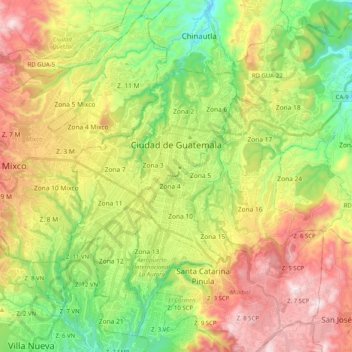
Name: Guatemala City topographic map, elevation, terrain.
Location: Guatemala City, Guatemala Department, Guatemala (14.53641 -90.58709 14.71379 -90.38541)
Average elevation: 1,538 m
Minimum elevation: 1,164 m
Maximum elevation: 2,038 m
Other topographic maps
Click on a map to view its topography, its elevation and its terrain.
La Pista
Guatemala > Guatemala Department > Guatemala City
La Pista, Colonia Las Victorias, Zone 1, Guatemala City, Guatemala Department, Guatemala
Average elevation: 1,465 m
National Palace of Culture
Guatemala > Guatemala Department > Guatemala City
National Palace of Culture, 6a Calle, Zone 1, Guatemala City, Guatemala Department, 01001, Guatemala
Average elevation: 1,485 m
Zona 12 de Villa Nueva
Guatemala > Guatemala Department > Villa Nueva City
Zona 12 de Villa Nueva, Villa Nueva City, Guatemala Department, Guatemala
Average elevation: 1,384 m